You are probably familiar with at least one type of sea urchin (hyperlink: https://en.wikipedia.org/wiki/Sea_urchin). They are round-ish and covered in spines of various shapes and colours. Many can be found on coral reefs and others dig themselves into the sand, dirt or mud of the sea floor.
But did you know that sea urchins of certain species can be found in large groups called ‘herds’? And what tell-tale signs underwater would a herd of sea urchins leave behind to give you a clue that they are nearby?
A few days ago, scientists from AIMS, CSIRO and the WA Museum got to find out!
What were the signs left by the herd?
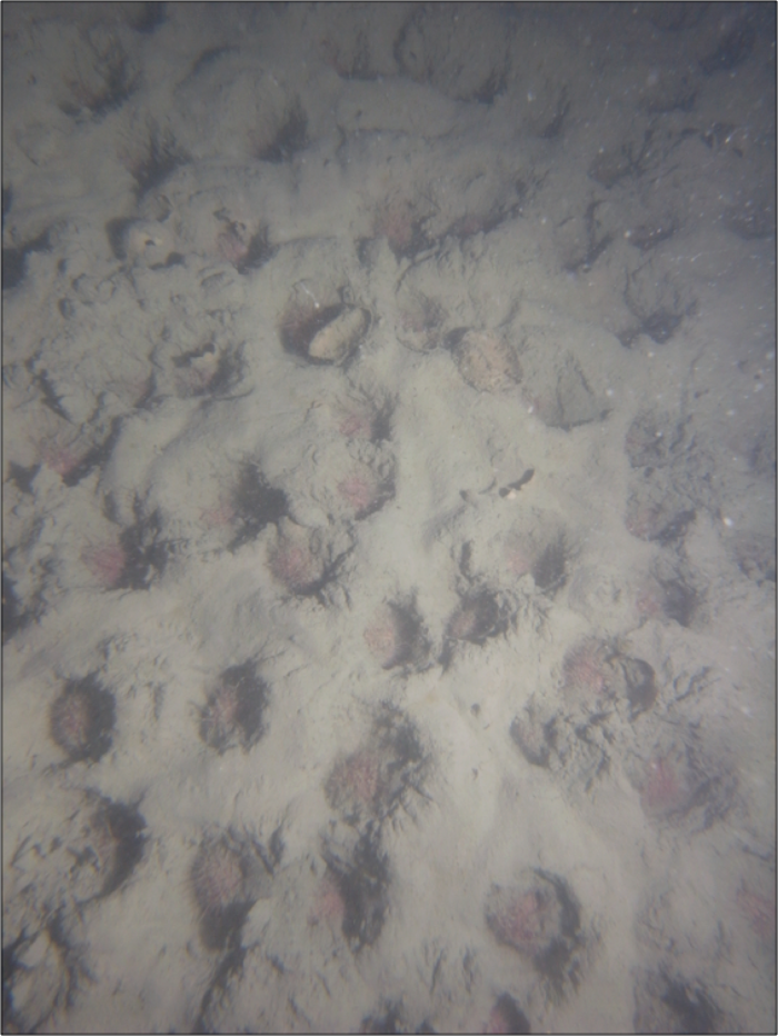
We were using the AIMS towed video system to film and take photographs of the sea floor (see previous blog ‘Exploring the Sea Floor with Towed Video’). Checking the data afterwards, we could see a distinctive pattern in the mud on the sea floor (see below) which was present in almost every one of 250+ photos taken along each of three separate 1.5 km transects.
Distinctive patterns evident in photographs taken by the AIMS towed video system
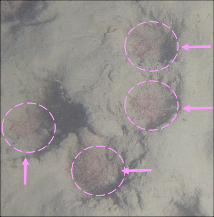
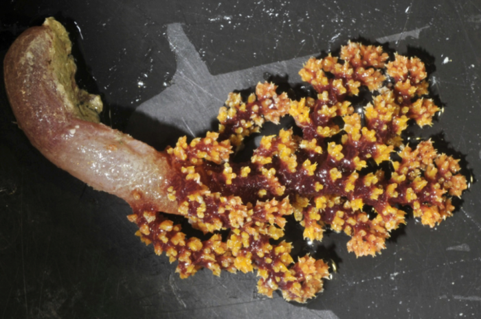
Examining the photos closely with John Keesing of CSIRO, we realised that the holes in the sea floor were burrows very likely excavated by the pink creatures nestled inside them (see below). From the photos and some research, John has confirmed that these creatures are heart urchins, specifically ‘petalled heart urchins’ (Metalia dicrana).
Close-up of still photograph showing individual burrows with the urchins that created them nestled inside.
Urchins that live on coral reefs have heavy jaws to help them eat seaweed which is tough to chew. Heart urchins live in mud or sand and eat little bites of much softer food. In John’s experience, heart urchins are often found either on the surface or deep inside burrows where they can’t be seen. This was the first time he observed them to sit in shallow burrows – perhaps using the burrows to collect small food particles to eat. In the Indian Ocean, these urchins have previously been observed at the Rowley Shoals (17.33 degrees South, 119.33 degrees East) and Ashmore Reef (12.25 degrees South, 123.14 degrees East).
How could we be sure it was a heart urchin herd?
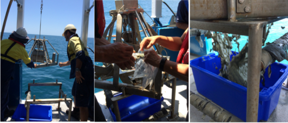
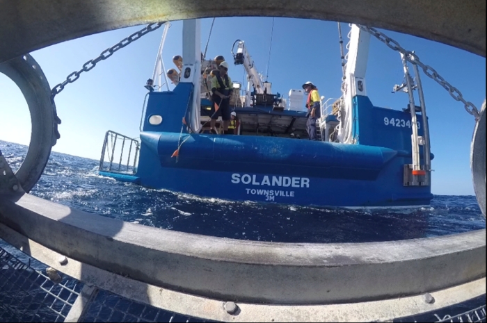
Our cruise leader, Karen, decided we should collect bottom samples from the area where we saw evidence of the heart urchin herd using the sled (see below).
Clockwise from top left: RV Solander crew secure the sled back on deck, WA Museum scientists search for creatures in the very muddy sample from the sled, some of the many heart urchins that they found wait to be photographed by CSIRO scientist John Keesing.
As expected, we found many urchins in the very muddy sample, and John confirmed that they are heart urchins.
How wide ranging are the heart urchin herds?
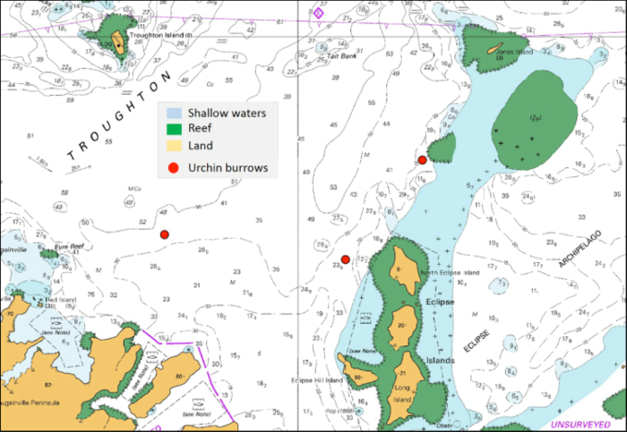
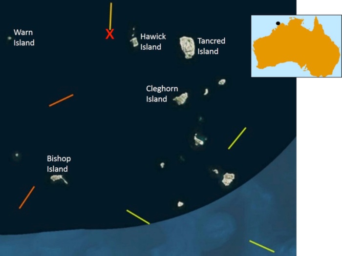
So far, we have found evidence of extensive tracts of heart urchin burrows in three locations: two on the western side of the Eclipse Islands (see map below), and one further to the west in the Troughton Passage between Troughton Island and the Eclipse Islands. We did not find many burrows in surveyed locations further west than this, at Troughton Island or along the Bougainville Peninsula, nor further north towards East Holothuria Reef (off the map to the north-west).
Locations where we found extensive tracts of heart urchin burrows near the Eclipse Islands, north-western Australia, 18.85 South, 126.33 East.
Later in our expedition, we will explore the eastern side of the Eclipse Islands and in the north-eastern section of Troughton Passage (further north than the top of the map above).
Welcome back! Today (Wednesday 16 December 2915) was the last day of our expedition through north-west Australia’s remote Kimberly coastal waters. Our study area covered part of the Bonaparte Archipelago. The last stage of the journey is to steam back to port in Darwin which will take about 40 hours.
And, though it started with a thunderstorm, today turned out to be the best day yet. In this blog, I’ll show you some highlights from a reef walk we did on West Montalivet Island, show you a a video of the most stunning undersea sponge gardens we’ve seen so far on this trip, and introduce you to the sounds of snapping shrimp and whistling dolphins that we recorded in the waters near Cape Chateaurenaud (northern tip of Bigge Island).
The entire study area with key places mentioned in tiday’s blog marked wirh red stars.
At long last- time for a reef walk!
Because most of the places where the water was deep enough for us to visit with the RV Solander was covered with soft sand or mud, we saw very few hard corals during our trip. Baby hard corals must anchor themselves to a hard surface (like a rock) in order to survive. So, even a morning thunderstorm couldn’t dampen our enthusiasm to get up close and personal with a coral reef!
We split into two teams: a beach team and a reef flat team. I was in the beach team. Solander crew Scotty took us out in the zodiac (small inflatible boat) as close as he could get to the island. Once we hit lots of coral Bonnie’s in shallow water, we jumped out of the zodiac and our reef walk began! As it turns out, steel capped boots are not only perfect for working on deck, but they also work a treat for walking on sharp dead corals and climbing slippery sea cliffs!
Marji riding in the zodiac and then atop a sea cliff on West Montalivet island as the tide drops to its low point for the morning. The RV Solander is anchored in the background in the right- hand photo.
First up was an exploration of the sea cliffs that framed each of the two beaches we walked along. The rocks provided evidence of the extent of high tide- rocks typically underwater at high tide were darker in colour, covered with algae, and very slippery (see above). Rocks not typically underwater were an artist’s palette of red ochres, yellows, and greys (see below). Tide pools were formed in the cracks between the rocks even stop the higher cliffs.
Examples of beach rocks we saw at the north-west corner of West Montalivet, which formed magnificent cliffs that framed the two beaches we visited.
Of course we had to explore the fringing reef just off the beach! It was chock full of partially submerged hard corals that we saw are branching corals (see below) and brain corals (see next set of photos). Branching corals do just as their name suggests- they grow in a series of branches made up of thousands of individual, tiny coral polyps (look closely in the right-hand image to see them).
Branching hard corals (Acropora spp) observed in a shallow fringing reef on the north-east corner of West Montalivet Island
Brain corals also look just like you’d expect from their name. In the picture below,you can see how the individual polyps combine to form structures that look just like the twisting and turning folds inside a human brain!
Brain corals observed in a shallow fringing reef expised at low tide on the north-east corner of West Montalivet Island.
Meanwhile, the reef flat team headed over towards an extensive reef flat further to the north. They had great fun searching for critters to capture in their white buckets.
A view of the extensive reef flat on the northern corner of West Montelivet Island. Johanna, Janelle, and Ollie ready for action with their collecting buckets.
All too soon, it was time to return to the Solander to complete our last towed video transect and last sled for the trip.
Who will find the best sponge gardens?
Yesterday, we completed our last planned towed video transect and could start using results from Nick and Iain’s multibeam sonar data to try to find ideal spots for corals and sponges to live. As I said earlier, much of the sea floor in our study area deep enough for the Solander to visit has been made of soft sand and mud. But sponges and corals need something hard (like a rock) to anchor themselves against the raging tidal currents in this part of the world. The difference between high and low tide can be as much S 4 to 6 metres!!
Yesterday, I posted a video on You Tube that showed lovely sponge gardens at a spot between South Maret Island and Berthier Island that Marcus picked. We called this ‘Marcus’ Sponge Wonderland’. Today we ran the towed video over a rock that Nick detected using the multibeam data. The spot we named ‘Nick’s Rock’ was absolutely stunning- colorful fish were zipping through dense undersea gardens of sponge and soft corals. If you watch closely, you can see brittle stars and feather stars crawling on top of sponges, sea fans, sea whips, and of course lots of different types and colors of sponges.
Watch the video of sponge gardens at Nick’s Rock.
See if you think that Nick’s Rock is best by comparing it to the also gorgeous video from Marcus’ Sponge Wonderland.
Yesterday, Iain took a great photo of two green sea turtles near the Maret Islands (see below). We also saw a white tipped reef shark and a school of Giant Trevally.
Green sea turtles frolicking right at the bow of the RV Solander on 15 December 2015.
What does a coral reef sound like?
Speaking of Iain, at the start of our trip, he put an instrument in the water on the north side of Bigge Island to record underwater sounds. After two weeks, we picked tge instrument back up and he has started sifting through the data it recorded.
The picture below is a spectrogram. It shows you on a picture when sounds occurred, how high or low pitched they were (the frequency), and how loud they were (colors; blue=quiet, red=loud). Click on the picture to hear the sounds recorded over one 4.5 second time window. In that time, you can hear two dolphin whistles (circled in yellow on the picture) and lots and lots of the clicking noise made by snapping shrimp. It is because of that clicking sound that I think diving or snorkeling on a reef sounds like marbles bouncing on a tiled floor.
Above the white line on the picture are sounds that human ears can’t hear. If we we could, we’d hear dolphin clicks. Dolphins use their own version of sonar to navigate and find food. They make sound (the clicks) and the time it takes for the sounds to return to them (and how loud the returning sound is) creates a map in their minds of their surroundings. Learn more about underwater animal sounds.
Farewell from the RV Solander
The crew of the Solander, as always, did an amazing job. And my fellow scientists were a pleasure to work with- spending every waking moment together for nearly three weeks. Thanks to all!!
Everyone except Deano gathers on the back deck for a farewell photo as we steam our way across the Joseph Bonaparte Gulf on our way back to Darwin.
One of the benefits of working on a ship is a panoramic view of the sunset every night. On the NE Atlas channel on You Tube is a video showing my favorites from each day of the trip. Below are three of them.
Spectacular sunsets are one benefit of journeying on the sea
I hope you enjoyed this blog! Thanks for reading 🐠🐠🐠
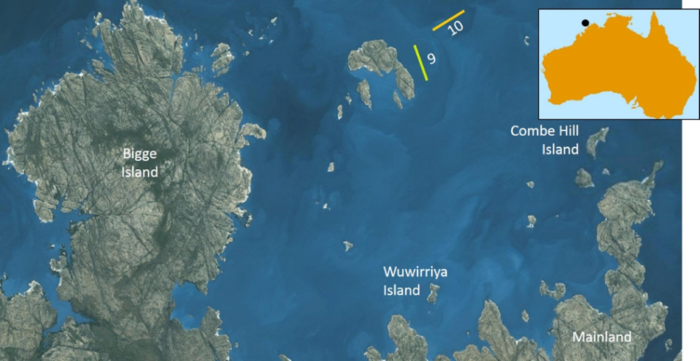
We just finished day 9 since arriving in the study area. It is Saturday 12 December 2015. Today our focus was on the far south-western part of the study area between Bigge Island and the mainland (see map below). Because this area is poorly surveyed, we had to carefully multi-beam it first to ensure no shallow areas not marked on the nautical charts would surprise us.
Our focus area for 12 December 2015. We did towed video transects number 9 and 10, but had to mult-beam them first for safety reasons.
Most of the sea floor that we’ve surveyed so far has been made mainly of mud. Some of it thick, sticky and stinky. And, though you may never have thought about it, mud is heavy.
To find out what is living in all that mud, we collect critters from the sea floor with the sled (see earlier blog about how we use sleds). Before we do that, we need to know what the sea floor is like. If the sea floor is mostly hard or likely contains large sponges or corals, then we need the AIMS sled because it has a larger opening and digs deeper into the sea floor. If the bottom is mostly soft mud, then the CSIRO sled works better because it is less likely to collect too much heavy mud.
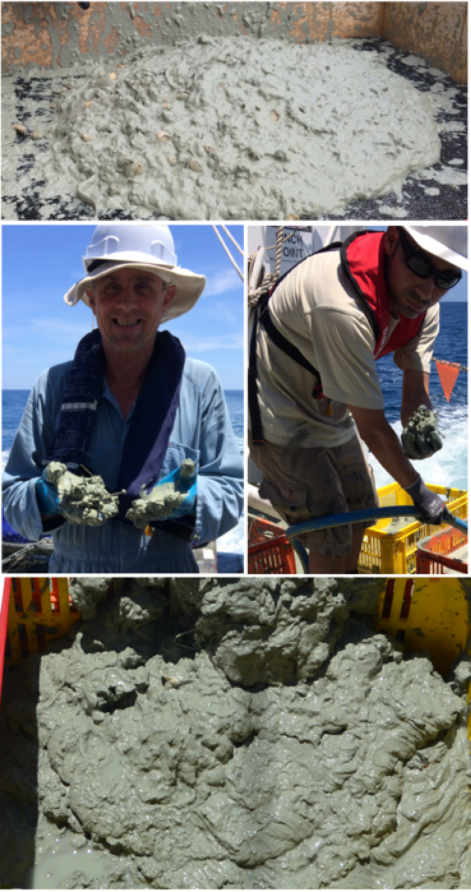
In fact, we got a surprise when we used the AIMS sled just south of Championet Island on the western side of Bigge Island on 6 December. The sea floor was muddier than we expected even though we checked with a grab sample first (I’ll explain how we do grab samples next). It was so muddy that the net of the AIMS sled was overflowing with mud to a height of at least 2 metres and a width of a metre (see below).
The Solander’s crane fails to heave the ‘massive sled that never was’ onto the back deck – too much mud, mud, and more very heavy mud!
All that mud was so heavy, that after an hour of intense effort, the Solander crew were unable to lift the net on-board even using the Solander’s heavy duty crane. We had no choice but to empty the net back into the sea. I suspect that the Australian Museum scientists were secretly relieved because sorting through all the critters living in that massive blob of mud would have taken them a very, very long time!
How do we check what is on the sea floor?
We can do a quick check of what is on the sea floor in a given location by using a grab sampler (see below). We use the Smith and MacIntyre Grab
Solander crew use the Smith and MacIntyre Grab to take a sample of the sea floor.
First, the skipper slows the boat to a stop. Then the crew use a winch to lower the Grab to the sea bottom. Once it hits bottom, its jaws open to grab a sample and then they spring shut. After the Grab is winched back on deck, scientists scoop out a sample for analysis. Watch out while the sample tray is emptied – SPLAT!
What lives in the mud?
The grab sample doesn’t tell us much about what creatures live on the sea floor. For that, we use a sled. Surprisingly, lots of creatures of many different types live happily in the mud. But it takes a dedicated team of scientists to search painstakingly through all the mud to find them (see below).
Examples of very sticky and stinky mud from the CSIRO sled. John from CSIRO and Ollie from the WA Museum start the process of finding the creatures hiding in the mud.
All that effort is worthwhile to discover the amazing array of creatures that make their home on the muddy sea floor. Below is a sampling of some of them, as photographed by John Keesing of CSIRO.
You have probably seen crustaceans before if you like to eat seafood. Crabs, prawns and bugs are all crustaceans, as are lobsters. Crustaceans usually have a skeleton outside their body (a hard shell that is part of their body) and two antenna to help them sense the world around them. Can you find the hard shells and antennae on the crustaceans below?
Examples of crustaceans we found living in the mud, from top right: crab, bug, shrimp (a small version of a prawn).
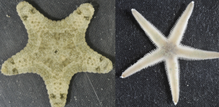
Sea stars normally have 5 arms, but some have more. If they lose an arm, it can grow back though it might take days to months. In the pictures below, you can see the underside of the sea star. Look closely to see its mouth.
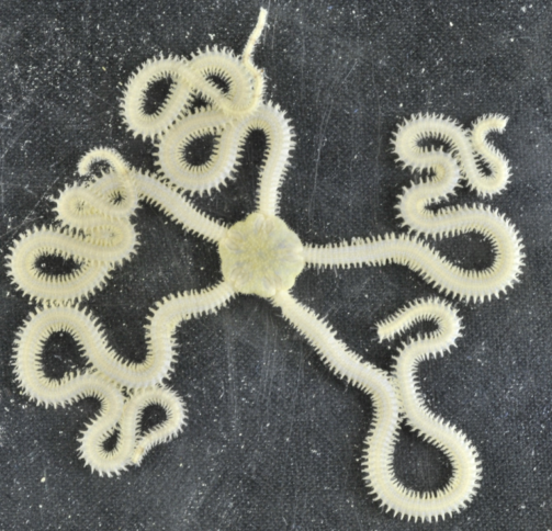
Brittle stars are similar to sea stars, but with longer and more flexible arms. Usually they have 5 arms, which they use to crawl across the sea floor.
Example of a brittle star we found living in the mud.
some gastropods live in shells which they carry around with them, just like a turtle. They do this to protect their soft bodies from being eaten. As they grow, they have to find new shells to move into. In the photos below, look closely to see the animal living inside (and poking out of) the shells.
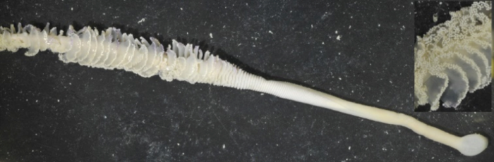
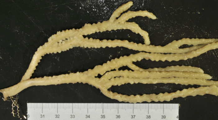
Sea pens are named after the quills (feathers) that people used to write with in the 1800s by dipping them in ink. In the picture below, notice how the sea pen is long and thin with feathery bits on the end – just like a quill. A sea pen is actually made up of many polyps that work together to create a colony – just like in a coral. Unlike soft corals, sea pens like to attach themselves to the sea floor by digging into sand or mud.
Example of a sea pen we found living in the mud. To the far right is a close-up of the feathery bits of the sea pen.
Fish
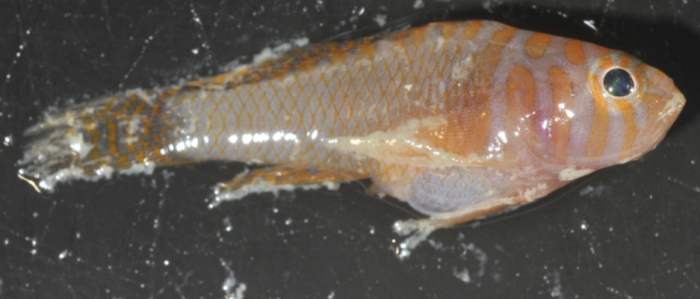
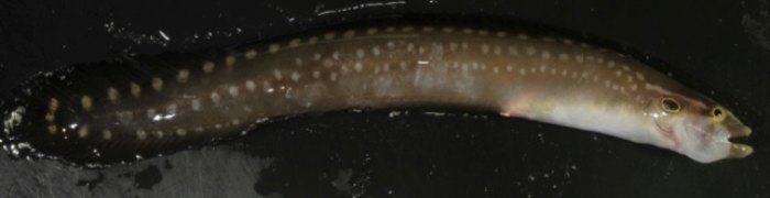
Many types of fish like to eat the small creatures that live in and on muddy sea floors. The lower picture is an Eel . Even though the eel looks like a snake, it is really a fish.
Example of fish found in the mudExample of Eel found in the mud
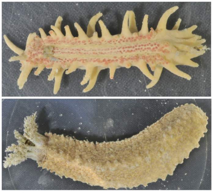
Sea cucumbers have long thick worm-like bodies with leathery skin. They have tentacles around their mouths, and a series of tube feet along their bodies. See if you can find the tentacles on the sea cucumbers in the photos below. Try to count how many tubed feet they have.
Examples of sea cucumbers we found living in the mud.
Soft corals are actually a group of many separate animals (polyps) that work together to form a colony. Hard corals make their own skeleton outside their bodies for protection. Soft corals also create protection for their bodies – but in the form of tiny, spiny elements called sclerities. So soft coral bodies remain flexible.
Example of a soft coral we frequently found living in the mud.
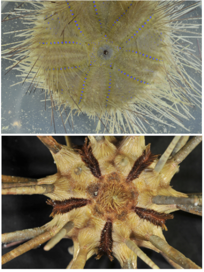
Sea urchins are small (usually 3 to 10 cm across), round animals covered with spines. Sea urchins like to eat algae. Lots of animals like to eat sea urchins, including sea otters, starfish, and some kinds of fish. Look at how different the spines look on the two sea urchins below.
Examples of sea urchins we found living in the mud.
Did you know…?
A sea pen can grow up to 2 metres long.
Many people in south-east Asia and China love to eat sea cucumbers. Some even use dried sea cucumber to make chocolate chip cookies!
The largest brittle stars can have arms up to 60 cm long.
Scientists are urging Australians to start eating sea urchins.
Why is the mud in our study area so stinky?
We are surveying the sea floor in relatively shallow waters (20 to 45 m deep). Lots of organic matter (dead bits of plants and animals) constantly lands on the sea floor. The bacteria that love to eat organic matter need to use oxygen dissolved in the water to be able to digest it. But they run out of dissolved oxygen before they run out of food. So they use different forms of oxygen that release sulfur – and make that very stinky rotten-egg smell. If we collected mud from very deep waters, the mud would not stink because the bacteria would be able to eat all the organic matter without running out of dissolved oxygen.
Welcome back! We are now on day 7 since arriving in the study area. It is Thursday 10 December 2015. Yesterday and today we are working around West and East Montalivet Islands (see map below).
Area surveyed by RV Solander on 9-10 December 2015. The towed video transect near Biddles Rock is marked with a red X.
A welcome surprise
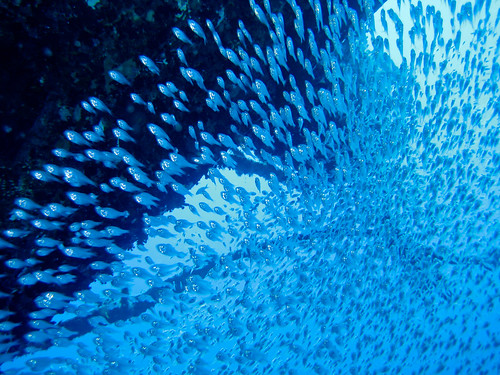
After a full day of watching nothing but sand, sand, and more sand appear on-screen from the AIMS underwater towed video camera, Marcus and Neill got a big surprise while running a transect north-west of Biddles Rock (see map above).
Watch the video below for a short example of what they saw. Watch out for a quick glimpse of a pink sea anemone
Video of AIMS towed video moving through a fish swarm
Fish swarm at Biddle Rocks
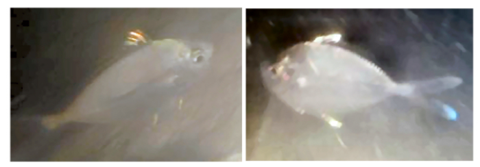
The towed video was moving through a large group of fish swimming together – sometimes called a swarm. According to Mike Cappo, a fish expert from AIMS, these fish (see below) are most likely ponyfish, known to local trawlers as ‘snotties’.
Two examples of ponyfish swimming in the swarm the AIMS towed video passed through
As you saw in the video, these fish darted to and fro very quickly, making it tricky to capture a clear image of a single fish. That’s why we can’t tell you exactly which kind of fish they are.
What is a fish swarm?
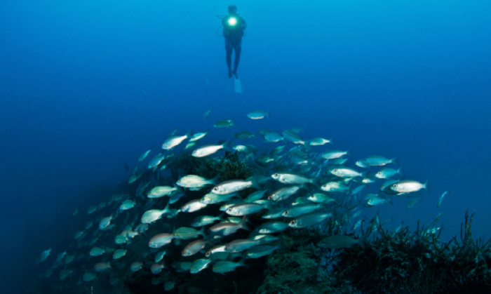
A swarm happens when animals of the same type and of a similar size group together and move as one. With birds, it is called flocking. With zebras, antelope and sheep, it is called herding. With fish, it is called shoaling (if they are gathered together for social reasons) or schooling (if they are swimming together).
Here are some examples of what other swarms of fish looked like when viewed through much clearer water than what we have today on our trip:
Scientists have lots of ideas about this, including:
Large groups of similar looking fish swimming together may confuse predators who have trouble selecting a single fish to eat.
Hunting together may make it easier for swarming fish to find food.
Swimming close together may make it easier to swim just as when the lead cyclist creates easier riding conditions for the riders immediately behind.
How to find a fish swarm?
One way is to accidentally drive the tow video system through the middle of one, like we did!
Otherwise, groups of fish swimming together are easy to detect using sonar. Remember from an earlier blog that I told you we are mapping the seafloor using sound. Watch a video of how it works
Our multi-beam sonar sends sounds downward and the time it takes for them to reach the bottom, bounce off it, and return to the sonar array on the ship tells us how deep the sea floor is.
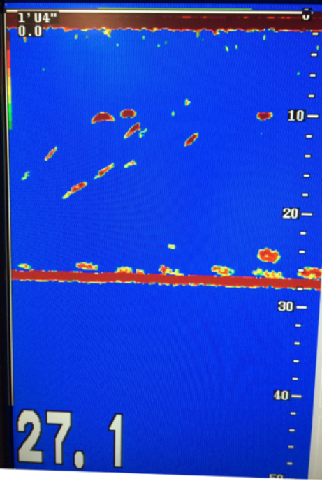
The Solander’s depth sounder works in a similar way. Once I dragged myself away from watching the swarming fish on the live feed from the towed video, I captured a shot of the Solander’s depth sounder (below).
Parts of the fish swarm can clearly be seen on the depth sounder (red blobs).
Red on the depth sounder picture below indicates a strong sound pulse received by the sonar. The solid red line at about 27 metres depth is the sea floor, where you’d expect to get lots of sound bouncing back to the sonar. The other red blobs throughout the water column are groups of fish. You can see why depth sounders are also known as ‘fish finders’!
Welcome back! On the RV Solander, we are criss-crossing through our study area mapping the sea floor with multi-beam sonar (see previous blog ‘Mapping the sea floor’) and doing some sleds (see previous blog ‘Taking a close look at the sea floor’). One thing you may not have thought about is that we are in the tropics during summer.
Because we are relatively close to the equator (our latitude is ~14.5 degrees south), the weather is very hot and humid – sultry, in fact! In this part of the world, the winds in summer tend to be relatively calm. Indeed, we’ve experienced near still waters on many a morning (see previous blog ‘Buzzed by sharks’).
Everything changes very quickly, though, if a small but intense storm – called a squall passes over us. Squalls are relatively common in the tropics in summer and we’ve already experienced a few on our journey. In today’s blog, I will show you an example of what happens when a squall passes over a ship at sea.
What is a squall?
A squall is characterised by a sudden and dramatic increase in wind speed and the onset of rain. When you are at sea, the strong winds whip up whitecaps on the water, in starts to rain, and it is time to ‘batten down the hatches’! Historically, this meant to close all the doors (hatches) on the ship and use wooden battens to make sure they stayed closed as the weather got rough. For us, it means to secure all gear that is on deck so it doesn’t blow away or slide off the side.
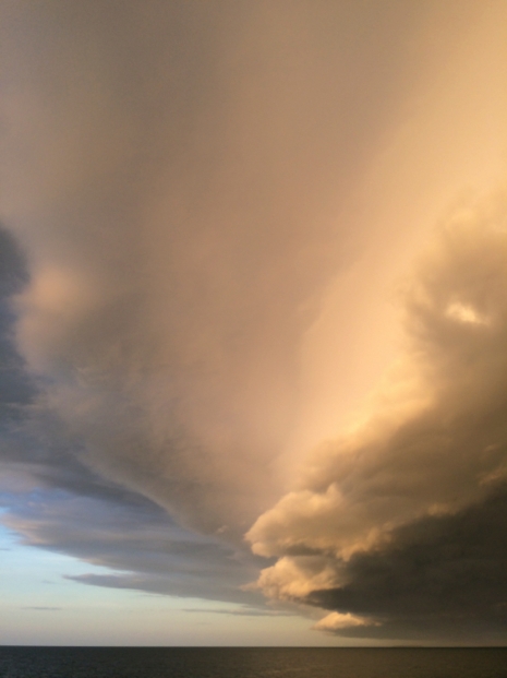
Yesterday (13 December 2015), we were in the middle of a towed video transect, oohing and ahhing at live video of sponge gardens near Ripple Rocks (eastward of the Maret Islands) when we realised a squall was headed our way. I ran out on deck to take pictures of the dramatic, towering squall line clouds about 10 minutes before they engulfed the RV Solander. In the picture below, notice how the cloud layer closest to the ocean is very dark.
One section of the dramatic clouds that made up the squall line that engulfed the RV Solander near the Maret Islands.
The photo above captures just one small section of the awe-inspiring squall line clouds we saw. Watch the movie below to see what the entire squall line looked like before it passed over us:
The very calm seas around us made a stark contrast with the roiling clouds in the distance (see picture below).
Two views of cloud layers visible from the RV Solander yesterday near Maret Island. Look closely and you can see the rain falling from them onto the sea.
The squall passes over
Within minutes, the squall began to move over the ship. The darkening clouds gradually took over, until only a sliver of sky remained streaked by the sun setting behind the Maret Islands (see below). You can’t tell in the picture, but the wind was blowing so strongly I could barely hold my camera. Gusts of wind sent horizontal streamers of salt spray scudding across the rapidly building waves. The picture does not do justice to how surreal it was to watch the peaceful scene of golden sunset gradually give way to relative darkness.
It was time to pull in the towed video and secure it on deck (see below). All of this was done just in time as the rain set in and dinner was served.
Dave, Niell and Marcus start to pull in the towed video and secure it on deck. Notice how the orange towed video cable is off at an angle to the far right as the wind was blowing the ship off course.
No lightning struck near us or was visible during yesterday’s squall. We did see some lightning on 6 December when another squall passed over the Solander. I don’t have pictures of it as it was already dark when it happened. Rob estimated wind gusts of about 60 knots (for about 30 minutes).
Watch a video of lightning I filmed in thunderclouds in the distance earlier in our journey. That storm front never reached us.
Tracking a squall
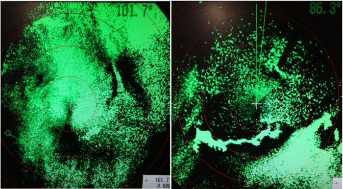
On-board, we use weather radar to track the passage of the squall or even a larger storm. Weather radar (see examples below during two squalls that passed over the Solander during our journey so far) uses a sound pulse just like sonar, but through the air instead of through the water. When the sound pulse hits an object, it bounces back to the ship’s radar sensor. The time it takes to bounce back and how strong the sound is that makes it back helps determine where rain is falling and how much.
Examples of radar displays on the Solander captured during squalls. In the right-hand image, the nearby islands show up as a very bright continuous shape.
We just finished day 8 since arriving in the study area. It is Friday 11 December 2015. Today our focus was on the south-east of the study area (see map below).
Focus area for the RV Solander today. Yellow and orange lines show where we used the towed-video system and collected critters from the sea floor. The red X shows where we were buzzed by sharks.
One of the first tasks for the start of each day is to take measurements of the ocean water’s key properties: conductivity, temperature and depth. Both conductivity and temperature affect how quickly sounds move through water. Knowing their values is thus important for making sure our multi-beam instrument is set up to work correctly as we map the sea floor.
We measure these properties repeatedly each day using an instrument we lower into the water called a CTD, as shown in the picture below.
The CTD instrument being lowered into the water using one of the Solander’s strong winches.
As you can see in the photo above, the sea today (as on several other days on this journey) is calm. Without a gasp of wind to stir the water, these quiet seas earn a 0 on the Beaufort sea state scale which measures how wavy the seas are. When the Solander is not moving (as in the picture), the seas are so still that you can look through them almost like a window to the deep – this is sometimes called ‘glass-out’ conditions.
The reflection of the sediment grab instrument is clearly visible in the very calm seas.
Because of this, when our instruments in the water caught the attention of three sharks, I was able to see them clearly through the water!
Buzzed by sharks!
As we lowered and retrieved the CTD and the sediment grab, three sharks repeatedly circled around the boat (see picture below). Can you find all three of them? Two of them are harder to see because they are deeper underwater. But all three are below the sea surface.
Three sharks swimming around the RV Solander while we stopped to take water measurements.Close-up view of two of the sharks through the water during ‘glass-out’ conditions.Check out the black tips on the fins
What is a spinner shark?
AIMS scientist Marcus Stower is reasonably confident that these sharks are spinner sharks due to the distinctive black tips on all of their fins. It is possible that they are black tipped reef sharks instead, but black tips usually don’t swim so close to the sea surface
Spinner sharks got their name because they often spin around at high speed towards the sea surface trying to catch fish. Sometimes they leap out of the water still spinning, as you can see in the video below.
AIMS have not been able to video or photograph spinner sharks leaping out of the water, but we’ll keep trying. Our tow-vid technician (Niall) has seen them leap out of the water repeatedly over the past few days. They sometimes chase the aluminium frame of the tow-vid system as it is winched to the sea surface. That gives me a good reason to put on my life vest, hard hat and steel toed boots so I can watch for them on the back deck!
Did you know…?
On average, spinner sharks are about the length of a typical adult human is tall (195 cm).
The longest spinner shark ever measured was 278 cm.
No human injuries or deaths have ever been reported from spinner sharks.
Mother spinner sharks carry their babies for 12 to 15 months instead of the 9 months for human mothers.
Spinner sharks prefer to eat fish that swarm. That may be why we are seeing them – remember from my last blog that we took underwater video through a fish swarm yesterday.
We are halfway through day 10 since arriving in the study area. It is Sunday 13 December 2015. Today our focus is on completing our last tow-vid transects near the north-eastern side of Bigge Island and further exploration of the eastern side of the Maret Islands, including a final towed video transect (see map below).
Map of the RV Solander research plan for today. We did towed video transects at # 11, 7, and 8, and sleds at # 8 and 11. This afternoon we are running multi-beam on the eastern side of the Maret Islands, and adding our last towed video transect (#56 !) near Ripple Rocks.
My last blog was all about mud and lots of it. Mud that has been very stinky! So when I learned that many types of nudibranchs might smell scrumptious – like lemons, watermelon vanilla or flowers – I decided that today’s blog should be all about these amazing creatures.
What is a nudibranch?
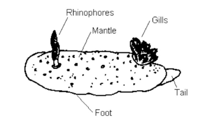
The word ‘nudibranch’ comes from the Latin words for naked (nudus) and gills (brankhia). Nudibranchs were given this name because they have gills sticking out of their backs, as shown in the diagram below.
Basic parts of a nudibranch.
Their main body cavity, which is often brilliantly coloured, is called the mantle. Nudibranchs also have two tentacles sticking up out of their heads called rhinophores. The rhinophores help them to smell food and detect smell signals left by other nudibranchs.
It is hard to see in the diagram, but nudibranchs move using a tube foot underneath their bodies. That’s right – they only have ONE foot. Can you imagine walking on one foot? As they move, slime oozes out of their bodies leaving a slime trail. This helps them to avoid getting lost. And, a nudibranch can tell where other nudibranchs are by smelling and following their slime trails. Some scientists suggest that a scared nudibranch’s slime trail will smell different than normal– thus alerting other nudibranchs of danger.
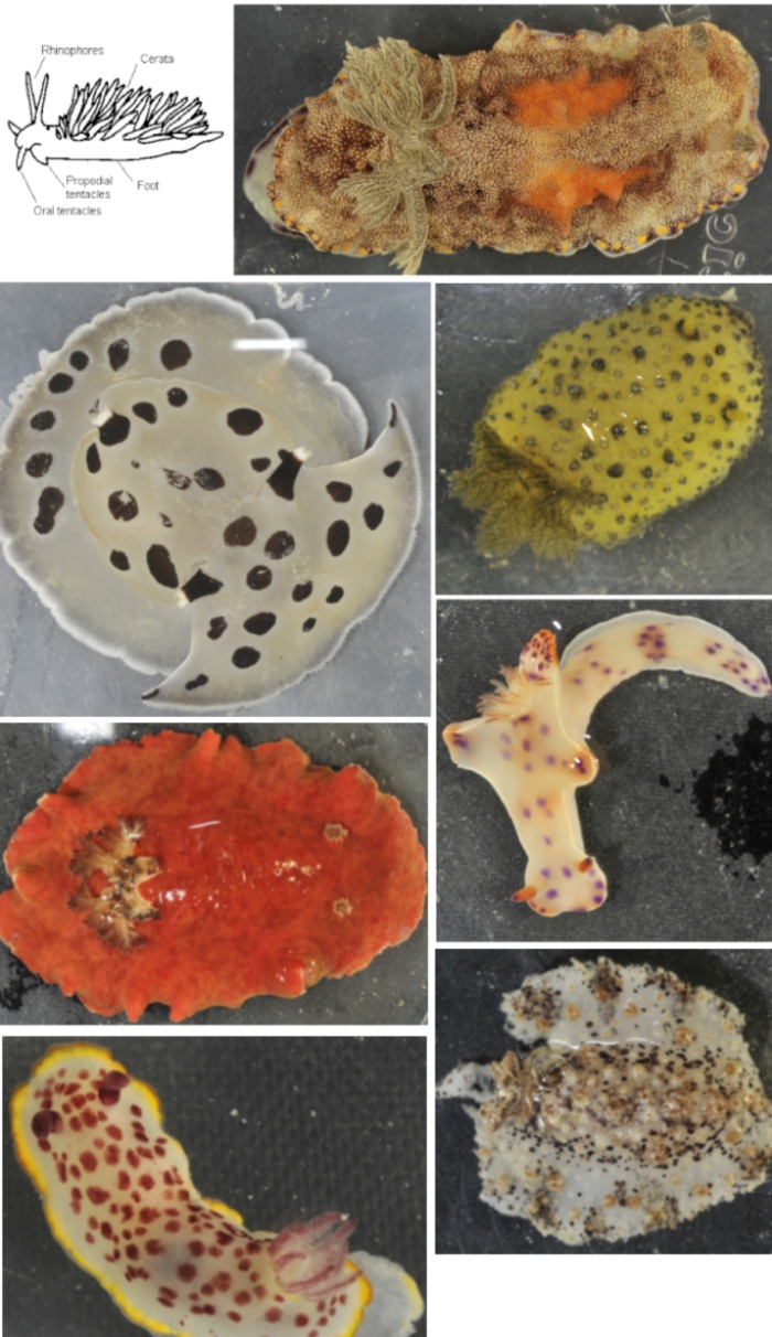
Below are some examples of nudibranchs that we’ve seen so far on this expedition, as photographed by John Keesing of CSIRO. Examine each nudibranch and look for its body parts.
Which nudibranch has gills that are hardest to see?
Which nudibranch has the rhinophores that are hardest to see?
Which two nudibranchs are showing their tube feet?
Nudibranchs observed during this expedition and photographed by John Keesing of CSIRO.
You are what you eat
Nudibranchs get their bright and varied colours from the food they eat: sponges, hydroids , bryozoans, and sometimes even corals . What nudibranchs eat can also help protect them from getting eaten by their predators.
As I told you in an earlier blog (‘Who lives in a pineapple under the sea?’), sponges contain lots of chemicals that can harm creatures that try to eat them. When nudibranchs eat sponges, they convert these chemicals into powerful toxins that can harm or kill other creatures that eat them. It is these toxic chemicals that some scientists suggest give off the aromas that smell delicious to humans – that is, if you get the chance to smell a nudibranch when it is out of water before it dies…!
Nudibranchs are also quite clever and will eat creatures that contain stinging cells – even the Portugeuse Man O’ War . The nudibranch does not digest the stinging cells or get harmed by them. Instead, the nudibranch uses them in its own body to protect itself.
Fully grown nudibranchs can be as small as 4 mm long and as large as 600 mm long.
Nudibranchs are both male and female at the same time!
A scientist in 1884 observed a nudibranch for 2 weeks. Over that time, he repeatedly heard it make a sound like metal clicking on glass. Modern scientists have not detected this – yet.
There are more than 3,000 known types of nudibranchs, with more being discovered all the time.
Most nudibranchs only live for a few weeks, though some live for up to a year.
Welcome back! We are now on day 5 since arriving in the Bonaparte Archipelago (Tuesday 8 December) and this is where we are.
Solander location 10/12/2015Today we are working north of Maret Island, in much deeper water (45+ metres deep) than yesterday. We have photographed sea floor habitats and critters along eight different 1.5 km transects with the AIMS towed video system, and collected 2 sled loads of critters from the sea floor to study.
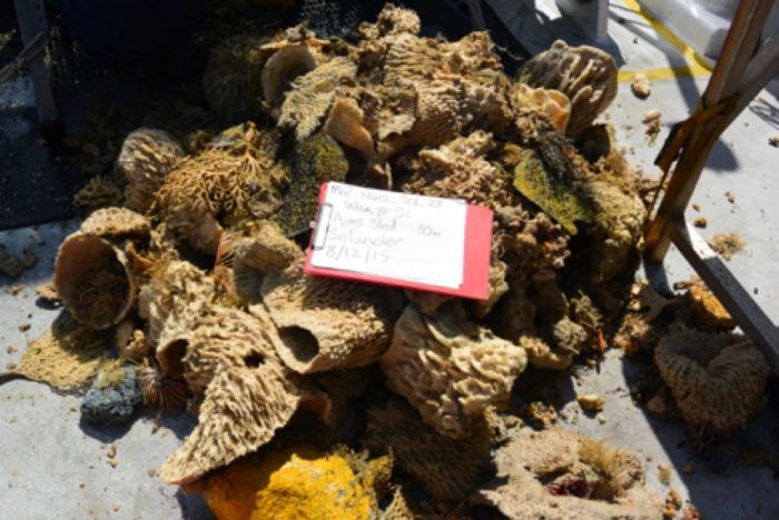
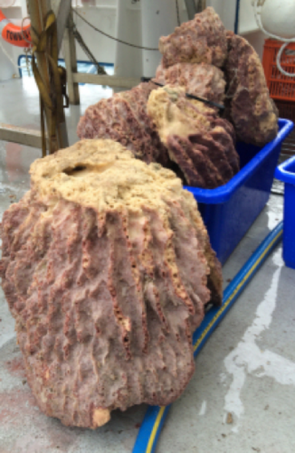
A highlight for the day was getting a close-up look at several large sponges (see below) before we headed northward. So, today’s blog is all about sponges!
Sponges collected from the sea floor by AIMS at north-west Maret Island in the Bonaparte Archipelago, Western Australia.Yes, sponges do indeed live under the sea. But of course they do not live in a pineapple, and in fact, they are only sometimes yellow like SpongeBob SquarePants.
What is a sponge?
A sponge is an animal with no muscles, heart or lungs! A sponge’s body is basically a U-shape – often like a barrel or a glass (see below). Spongebob Squarepants (and other kitchen sponges you may have seen or used) are actually just small pieces of the real sponge they would have come from.
An diagram showing the main parts of a sponge’s body (left) compared to an example of a real sponge filmed by AIMS towed video system (right). It is easy to see the central cavity (2) but you have to look closely to see the pores.Even though it has no bones, a sponge keeps its shape because it is filled with a jelly-like substance called mesohyl within a skeleton made of fibers rather than bones. Water comes in and out of the sponge’s body through holes in its body walls called pores (see above). The water brings food (tiny bits of debris and plankton) to every part of the sponge, and the water takes away wastes. All the pieces that fit together to make the sponge can work together to squirt water out quickly, such as to prevent burial under sand.
What shapes can a sponge be?
Sponges can form into many interesting shapes. Some common ones include:
Barrel
This type of sponge can grow up to 1.5 metres long – big enough for a person to stand inside it! The surface of these sponges often have deep ridges. 95% of all sponge species are of this type.
Examples of medium sized barrel sponges collected by AIMS near the Maret Islands in the Bonaparte Archipelago of Western Australia. They are upside down in the photo. See the ridges on the outside of the sponges?
Fan
This type of sponge can grow up to 1 meter long. They form a fan shape.
An example of a small fan sponge collected by AIMS near the Maret Islands in the Bonaparte Archipelago of Western Australia.
Tube
Tube sponges are made up of thick tube-like structures that join at the base. They can grow up to 1 metre in length. They can chase away predators by squirting out toxic chemicals.
An example of a small tube shaped sponge collected by AIMS near the Maret Islands in the Bonaparte Archipelago of Western Australia
Watch this video of sponges near Maret Island
How many barrel sponges do you see? Are they all the same kind?
Look closely to find the tube sponge towards the end of the video.
Do you see any fish or other creatures near or on the sponges?
Sponges are home to many small critters
You most likely saw fish swimming near some of the sponges in the video. And if you looked very closely, you may have seen little animals crawling on them. In fact, sponges are a very important part of the sea floor as they provide food and homes to many different types of animals like fish, starfish, brittle stars, feather stars, crabs, and more. In fact, some microscopic organisms even live inside the tissues that make the sponge’s body walls and give the sponges their colour.
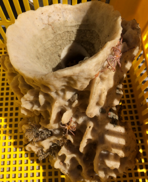
Look at the picture of a sponge below. Can you see the crab living on it? Can you see the pores?
A sponge collected by AIMS from the sea floor. Can you see the crab living on this sponge? Look closely to see the pores
Look at the sponge below closely. This time can you see the pores? What about the central cavity? How many critters can you spot living on it?
A barrel sponge collected by AIMS from the sea floor. How many critters can you spot on this sponge? On this sponge, it is very easy to see the central cavity but hard to see the pores.
Did you know…
New medicines for treating HIV and breast cancer have been discovered from sponges.
Sponges are common in Western Australia. 275 species of sponges have been found in the Damper Archipelago and 500+ at Ningaloo ReefNingaloo Reef.
This expedition is helping to figure out how many are found in the Kimberly region of Western Australia.
Many types of fish, nudibranchs, star fish, turtles and other animals depend on sponges for food and shelter.
Sponges are under threat from heavy fishing gear which drags along the sea floor and damages or kills them.
Welcome back! We are now on day 6 since arriving in the study area, see where we are . It is Wednesday 9 December 2015, and we’ve completed nearly half of our journey.
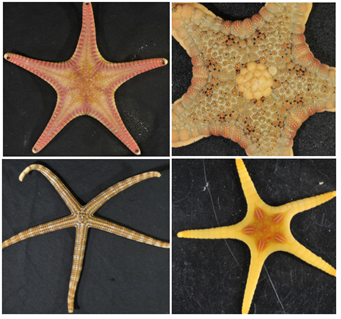
So far, we’ve seen many sea stars of all shapes and sizes (see some examples below).
Four examples of sea stars collected by WA Museum staff and photographed by John Keesing of CSIRO during this expedition.
Sea stars are marine animals that live throughout the world’s oceans. They have been found as deep as 6,000 metres below the surface.
They usually have 5 arms (as in the photos above), but some types have many more. If one of their arms gets chewed off or otherwise damaged, they can grow a new one! But it might take months to years to do so.
They have tube feet, but usually move quite slowly – a typical speed is just 16 cm per minute!
Sea stars normally eat tiny animals that live on the sea floor. But Tritons , crabs , fish, seagulls and sea otters like to eat them. Some sea stars try to stop other animals eating them by making chemicals to give themselves a yucky taste, or by oozing mucous (the slime star ), or by squirting poison, or by growing body armour!
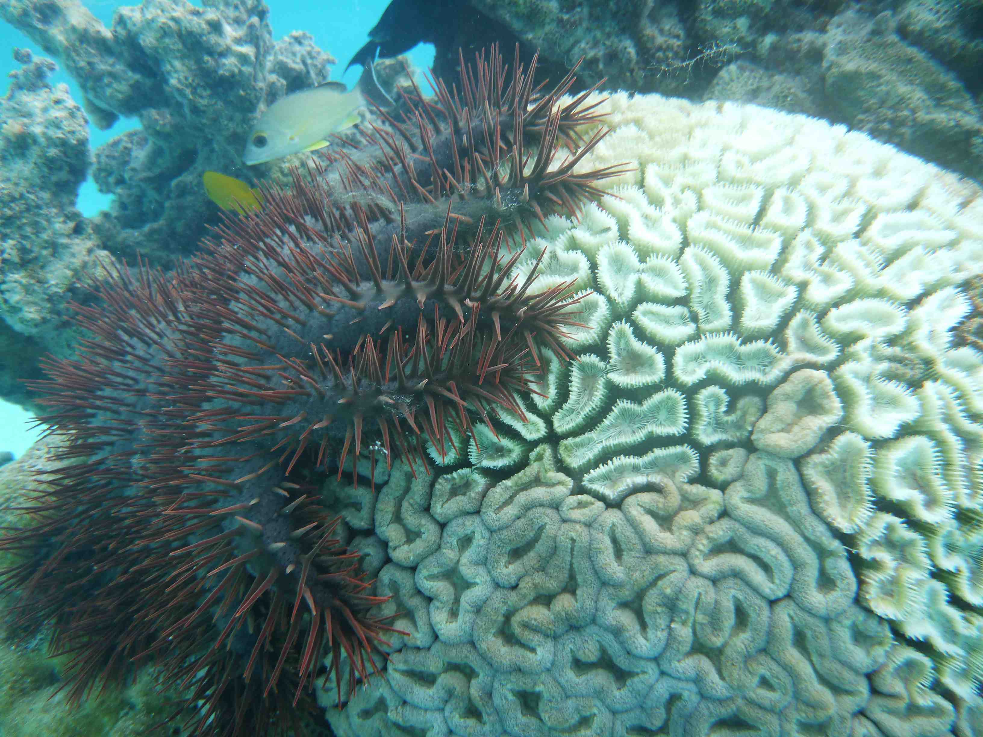
Today we confirmed that the AIMS towed video system (see previous post) detected a special kind of sea star – a crown-of-thorns starfish on the fringing reef at the north-west corner of Maret Island. This is important because this type of sea star – called COTS for short – prefers to eat corals and can destroy entire reefs under certain conditions.
What is a crown-of-thorns starfish?
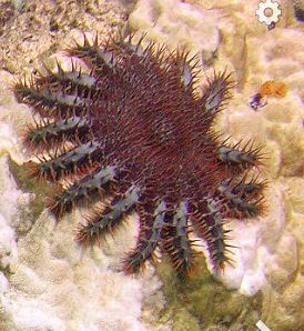
These sea stars, called COTS for short, prefer to eat corals – specifically the soft fleshy polyps that combine to form coral colonies. They get their name from the long sharp spikes that stick up all over their bodies which look like thorns (see below).
Crown-of-thorns starfish feeding on a reef. Photo courtesy of Rore bzh
Watch the video of the COTS we found at Maret Island
Look closely and see if you can spot it
Watch a video created by AIMS about COTS to learn more.
Look closely and see if you can spot it.
Did you know that the crown-of-thorns starfish…
• Is one of the largest types of sea stars in the world?
• Squeezes its stomach out through its mouth to put it directly on the coral it is eating?
• Can have up to 21 arms?
• Can give you a painful sting with the long, sharp spines?
• Under certain conditions, can destroy entire reefs in an ‘outbreak’?
Adult COTS feeding on coral. It pushes its stomach part way out of its mouth and digests the coral while sitting on it.
How do COTS outbreaks threat reefs?
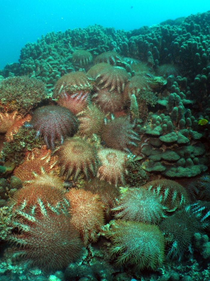
Under normal conditions, COTS exist on reefs in small enough numbers that damage to coral is minimal. Every now and then, however, conditions are just right to favour the survival and growth of COTS and their numbers reach plague proportions (see picture below). When this happens, it is called an outbreak and entire reefs over many kilometres can be stripped bare of live coral.
Four outbreaks of COTS have happened over the past 30 or more years on the Great Barrier Reef : the 1960s, late 1970s, early 1990s, and the current outbreak which began in 2010.
For example:
• Watch a map of how outbreaks of COTS have spread across the Great Barrier Reef over the past 30 years.
Recently COTS have been found in Western Australian waters around the Montebello Islands and some scientists worry that they may move southward and damage Ningaloo Reef
Because of this, it is very important to know that COTS also exist as far north as Maret Island so scientists can investigate whether they could pose a threat to the reefs of the Kimberly coast.
The COTS in the AIMS video above from Maret Island was clearly visible which means that it was an adult. Baby COTS tend to hide and are even hard to spot for divers looking closely to try to find them. This implies that more COTS might be present at Maret Island than just the one that we saw.
Welcome back! We are now on day 4 since arriving in the study area.
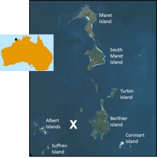
Today (Monday 7 December 2015) we are busy surveying around Maret Island, Berthier Island, Albert Island and Suffren Island (see map below).
RV Solander is surveying near the Maret Islands and vicinity today and tonight using multibeam sonar, towed video and sleds. The white X shows where we saw a turtle. The black dot on the map of Australia shows where the Maret Islands are along the West Australian coast.
We found a turtle!
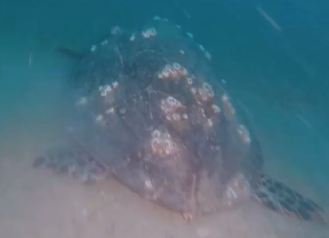
The AIMS towed video system (see previous post) found a hawksbill sea turtle lazing on the sea floor between Albert Islands and Berthier Island (white X on map above).
Hawksbill sea turtle observed by AIMS in the Bonaparte Archipelago, Western Australia. Can you see the barnacles growing on its shell?
Why is it called a ‘hawksbill’ turtle?
Hawksbill turtles have a mouth that look like a hawk’s beak. The narrow and curved shape of their mouth helps them search for food near coral reefs. Dr Scott Whiting from the Western Australian Department of Parks and Wildlife says that Hawksbill turtles in this region mainly eat sponges and sometimes seaweed.
Did you know that hawksbill turtles…
Spend the first 5 to 10 years of life drifting on ocean currents?
Hatch from eggs buried in the sand?
Are reptiles that need to breathe air?
Can hold their breath underwater for up to 7 hours if they are sleeping?
Why did we find it so far from home?
The size of the turtle we found means that it may be an adult. For this part of the world, that means it would be at least 30 years old. Over those 30 or so years, it has travelled a great distance from the beach where it most likely hatched from one of its mother’s hundreds of eggs. Dr. Whiting says that Hawksbills in Western Australia primarily nest at beaches on the Lowendal Islands, Montebello Islands and the Dampier Archipelago. These beaches are more than 1,100 km away from where we spotted the turtle today (see map below).
AIMS scientists observed the turtle (today’s location) more than 1,100 km from where it likely hatched (nesting beaches).
Amazingly, it is quite common for Hawksbill turtles to move to feeding grounds even farther away from the beach where they were born! Scientists have attached tags to turtles and found them moving as far as 2,400 km away from their home beaches. Some studies show that once turtles select a preferred feeding location, they sometimes remain in the area for years – surely by the time they travel that far, they need a bit of a rest!
Perhaps because they travel so widely, scientists have seen hawksbill turtles throughout the world’s tropical and sub-tropical oceans (see map below).
Locations where Hawksbill turtles have been seen (source)
Why are hawksbill turtles in danger?
Hawksbill turtles are identified as ‘critically endangered’ by the International Union for the Conservation of Nature (IUCN) and Natural Resources.
Threats to their survival in Australia occur when:
Hatchlings leaving the nest don’t reach the sea because they are led astray by artificial lights
Turtles are injured or killed when struck by vessels
Turtles are killed accidentally caught by commercial fishermen, especially trawlers
Turtles are killed or made ill by eating plastic or getting tangled in trash in the ocean
Turtles are killed or made ill by polluted waters
Fewer turtles hatch as beach temperatures getting too hot
Less space for nests as beaches get washed away by storms and sea level rise


